Monday, June 29, 2009

Brief warm up today

After a well deserved break from the heat and especially the humidity it is going to warm up a little today. Highs will be in the mid to upper 80's with maybe near 90 degrees near and south of Kansas City. But without the high humidity, the air wont be as steamy.

The reason for this warm up today is an approaching backdoor cold front pushing toward us from the northeast. The air is heating up out ahead of the front, but it wont be that bad.

The front should back through tonight and bring with it a c cooler airmass with a northwest flow. We may see some morning and overnight thunderstorm activity around with this northwest flow later this week.

Alex Pickman

Saturday, June 27, 2009

Hot Saturday then relief!

I havnt blogged in a long time due to vacation, and I was sick for three days.

Well it will be a very hot day today with highs in the mid 90's dominating the area. There will also likely be temperatures in the low 100's southwest of Kansas City. Accompanied with these high temperatures will be high dewpoints in the 70's. The hot weather and high humidity will cause heat indicies to be between 105 and 110. There may even be a couple locations to the south that see heat indicies of near 115!

As a result, the NWS has issued a Heat Advisory for the entire area, and an Excessive Heat Warning from Western Missouri including Kansas City and points southwest.

The good news though is that relief is on the way....by late this afternoon as a weak cold front approaches around 4-7 PM. This will knock down the temperatures and especially the humidity noticably. It wount come without a risk though as the is a slight risk of severe weather, but the odds of a thunderstorm hitting your area is pretty slim as the will be in a scattered line from Iowa to Oklahoma. Any storms that form can quickly become severe with damaging winds the main threat. There is a chance of some hail, but I would say up to nickel sized.

Once the wind picks up and you feel the shift, the threat of severe weather will be over, but there is some post frontal precipitation behind the front that may have some heavy rain with it.

I will update the blog later if any storms begin to form.

Alex Pickman

Thursday, June 18, 2009

Very hot day

It will be a very hot and humid day today with highs in the low to mid 90's and dewpoints in the 70's. Here is the forecast high temperatures for today:

With these temperatures and dewpoints in the 70's, heat indicies will likely reach greater than 100 degrees.

After this hot and humid day, a weak cold front will be approaching Friday, and with warm humid air out ahead of the front, the stage will be set for some thunderstorms, possibly severe. Highs tomorrow before the front should top out in the mid to upper 80's. The SPC has issued a moderate risk for northeast Missouri, but as you can see in the map below, the main threat lies across Illinois and Indiana pushing into the Ohio river valley.


This will be the last blog for a few days due to me leaving for a trip, I will try to get a blog in tomorrow morning, and maybe 1 in tomorrow afternoon if I can. There for sure will not be a blog Saturday, Sunday, and Monday.

Alex Pickman

Tonight's risk...Thursday weather

The thunderstorm threat is prety much over for the night and has shifted to the north into Iowa. There is an area of showers and thunderstorms tracking southeast in Iowa, and it may pose a threat to extreme northeastern Missouri.

Aside from the exterme northeastern corner of the state, the night should remain dry, warm, and humid, even hot in some cases. Salina Kansas jumped to 91 degrees at midnigh due to the sinking air from dying thunderstorms.

Now what about tomorrow's weather. I think it will be dry for us as a strong cap will be in place, but I would keep an eye on extreme northern Missouri as they are in a slight risk for Thursday. The main target will be across northern Indiana, northern Illinois, northern half of Iowa, and southern Minnisota. These areas are in a moderate risk tomorrow as you can see in the map below:


The threats for tomorrow in the moderate risk include very large hail, damaging winds, and tornadoes. Again, notice the slight risk across northen Missouri. We will have to watch this area closely if anything develops. I think it should remain dry for most locations, but very humid and HOT.
Highs should be in the low to mid 90's with dewpoints in the 70's. This will allow the heat index to break 100 degrees in many locations. I will update the blog tomorrow as it will be pretty miserable.
Alex Pickman

Wednesday, June 17, 2009

Tornado Watches!

Thunderstorms have formed in eastern Kansas and have rapidly become supercells. There have already been reports of a few tornadoes and huge hail up to baseball size! Here is the current radar image:


As a result of these storm forming, the SPC has issued 3 Tornado Watches, 2 of them for our area. Here are the Watches below.

This Watch is for North Central Missouri until 10:00PM CDT:


This next is for northwestern Missouri, southwestern Iowa, southern Nebraska, and northern Kansas until 9:00 PM;


There is a third watch that has just been issued for northwestern Kansas, western Nebraska, and northeastern Colorado.
These storms in northeastern Kansas, entering Missouri are very dangerous, producing very large hail, strong winds, vivd lightning, and possible tornadoes. There is only one Tornado Warning right now for exterme northern Atchison County, KS and southern Doniphin County, KS.
I will have an update soon.
Alex Pickman

Thunderstorms today?

Our area is in a slight risk for severe weather today with a moderate risk over Nebraska. Take a look at the map below:


Here is the breakdown of the risk area:


Here is what the NWS is saying abou the thunderstorm potential this afternoon and overnight:

WITH MORE STORMS LIKELY TO DEVELOP IN EXTREME NERN CO/WRN NEB AS LARGE SCALE LIFTING SHIFTS IN FROM THE WEST. ONCE SURFACE BASED STORMS DEVELOP...THE COMBINATION OF EXTREME INSTABILITY AND EFFECTIVE SHEAR AT 40-50 KT WILL LIKELY RESULT IN INTENSE SUPERCELLS WITH VERY LARGE HAIL. ALSO...SURFACE LOW OVER WRN KS SHOULD BACK LOW LEVEL WINDS AND STRONGLY VEERING WINDS IN THE BOUNDARY LAYER WILL BE FAVORABLE FOR A FEW TORNADOES. BY EARLY EVENING...THESE STORMS ARE LIKELY TO CONSOLIDATE INTO A LINEAR SYSTEM/EMBEDDED BOWS ACROSS ERN NEB/FAR NRN KS...AS LOW LEVEL JET STRENGTHENS. A FAST-MOVING MCS WITH WIDESPREAD WIND DAMAGE IS POSSIBLE OVERNIGHT INTO IA/NRN MO.
The best chance of thunderstorms in Missouri will be across the northern section of the state. The main threat then will be damaging winds and maybe some hail. Any rain will likely fall overnight in our area, so expect sunny, hot and humid conditions with highs in the lower 90's. Then a chance of some rain and thunderstorms tonight...possibly severe with damaging winds the primary threat. Thursday will also be a hot and humid one with low to mid 90's for highs. Another cold front will arrive sometime Friday with another chance of rain and storms.

I will update the blog if anything starts to fire or move near us.
Alex Pickman

Tuesday, June 16, 2009

Kansas storm..Rest of week's weather

Well not much is going on in our area, so I want to talk about a severe thunderstorm in southern Kansas, just south of Wichita. Take a look at the current warnings for the south Kansas area.


Cowell County, Kansas, just southeast of Wichita is under a Tornado Warning. It is very hard to see the tornado warned area as it is hidden within the darker red box. This dark red box is a Flash Flood Warning as this storm is just sitting there dumping rain.

Here is what the NWS is saying about the flooding rain.

AT 959 PM CDT...NATIONAL WEATHER SERVICE DOPPLER RADAR CONTINUED TOINDICATE A SLOW MOVING SEVERE THUNDERSTORM PRODUCING VERY HEAVY RAINOVER THE WARNED AREA. RADAR ESTIMATED RAINFALL RATES OF 2 INCHES PERHOUR WITH THIS STORM. THIS STORM COULD PRODUCE OVER 4 INCHES OF RAINFALL IN A SHORT TIME. FLASH FLOODING IS IMMINENT!

As you can see, there is a Severe Thunderstom Warning (in the pink), so more storm are possible. Other than a possible tornado indicated by dopplar radar, the main threat is flooding out of this storm.

Now lets look back up to our area for Wednesday's weather...High pressure is settling in and it is going to pretty warm if not hot. Highs Wednesday should top out on either side of 90 degrees. We will have to watch for thunderstorms late Wednesday as storms in Nebraska may make a run toward us, especially northern Missouri. It will be even hotter on Thursday with highs in the low to mid 90's. Another cold front will arrive sometime on Friday and there is a chance of some severe weather. I am not expecting anything like last night's MCS, but a slight risk exists.

Ill update the blog tomorrow on the warm up.

Alex Pickman

Monday, June 15, 2009

Thunderstorms moving through

Thunderstorms began to form earlier this afternoon across Western Kansas, and rapidly developed into a vigorous MCS (Mesoscale Convective System). Here is an infrared satelite image of this mature and impressive MCS over Kansas and Missouri:


Lets take a look at the current weather warnings for the area.


As you can see it is very colorful, so lets try to break it down a bit. The yellow in Kansas is a Tornado Watch which I am expecting to be allowed to expire soon unless there is redevelopment which is possible. The pink is the Severe Thunderstorm Watch. The Orange is a Severe Thunderstorm Warning and the green and red are flooding.

There have been reports of 60-80 mph winds some of these storms. The main threat in my opinion will be flooding. With dewpoints in the 70's this afternoon, the rain out of these storms will be very heavy, and I am expecting more tonight. One thing to note about these storms is that they are very electrical. There was over 20,000 lightning strikes in 10 minutes earlier around 10 PM.

I will keep you updated tonight

Alex Pickman

Morning thunderstorms...More rain?

A MCS developed overnight and pushed through the area, now we are dealing with the back side pushing through and there are some gusty thunderstorms on the edge near Kansas City. When all is said and done this morning, rain totals will likely be over an inch in most locations and in some spots over two inches.
After the rain stops, it wont be long before the clearing line gets to you. Here is the current satelite image:


Once the clearing line gets to you, the sun will come out and it will warm up quick and thanks to the rain, it will get humid. Highs should top out on either side of 80 degrees today. It will be a long break before our next rain chance comes in late tonight.

Notice the clear area across Kansas. There is a frontal boundary across Kansas and with high dewpoints and an upper level low moving across this area, the setup is there for showers and thunderstorms to form and they could be big. As a result, the SPC has issued a moderate risk across central Kansas.


Here is the break down of the risk area.


The tornado threat will be greatest over the moderate risk area as you can see on the map above.


Also the hail threat will be the highest over the moderate risk as any supercells that form will contain very large hail. Look at the map above.

There will be an increased wind threat overnight and the storms that form over Kansas this afternoon and evening willl likely develop into an MCS and spread into Missouri. There is a strong chance the storms will congeal into a line of storms and possibly a damaging bow echo. The bad news about this is that the storms will move into Missouri between midnight and 4 AM. So keep your weather radio on tonight in case of any Warnings.
I will have an update later today.
Alex Pickman

Tuesday, June 9, 2009

Morning thunderstorms

Thunderstorms developed in Kansas this morning ad have now pushed into Missouri. Some of these storms have been severe producing large hail. Here is a picture of the current radar image:


As a result the SPC has issued a Severe Thunderstorm Watch for eastern Kansas and western Missouri.


The SPC has also upped the risk for severe weather with areas in Kansas now under a moderate risk for severe thunderstorms with hail the primary threat.


The complex of thunderstorms that is in Missouri now is developing into a MCS as it continue to push east. I will have an update in a bit.

Alex Pickman

Monday, June 8, 2009

Monday weather...Next rain chance

Lets take a look at yesterday's severe weather reports:


There were 5 tornado reports in Missouri, but we will see how many are verified, but the most common reports in Missouri last night was the hail. The freezing point in the atmosphere was down to around 15,000 feet, and coupled with an enviornment suitible for very strong updrafts, very large hail was the result. There was one storm in particular yesterday that developed in Nebraska and quickly strengthened into a supercell. This storm did drop a couple tornadoes, but it also produced unusually large hail. Lake Viking, MO, just north of Cameron, MO reported GRAPFRUIT size hail for 10 minutes! The storm finally began to weaken as it entered Livingston county.

Yesterday was active, but it wasnt widespread. Now what about today's weather? There is still a chance of some lingering showers, but they should diminish and move to the east into Illinois. Skies should become partly cloudy and temperatures should be in the 70's and low 80's around the area making a pretty nice afternoon.

Our next chance of rain comes in tomorrow as a warm front lift north.


You can see the the warm front Tuesday afternoon in the map above. Here is the severe risk area for Tuesday:

The thunderstorm threat will continue into Wednesday. I will have a new blog tomorrow discussing the threat.
Alex Pickman

Sunday, June 7, 2009

Evening update!

Here is the current watches and warnings:


The Tornado Watch remains in effect until midnight tonight. Notice the Tornado Warning WNW of Chilicothee. There is a supercell thunderstorm moving southeastward producing GRAPEFRUIT sized hail and maybe a tornado! There have been reports of the funnel coming down and lifting back up. The Tornado Warning has just been extended to 9:45 PM as I am typing this. Take a look at the radar image below:


You can see the supercell thunderstorm in Daviess County, MO. I have drawn in the progected path based on its current movement. Remember, this storm is producing up to grapefruit szed hail which is 4 inches in diameter and has the potential to drop a tornado. Hail of that magnitude will cause significant damage, taking out crops, windows, large dents in vehicals, and stripping leaves from trees. Right now the storm appears to be weakening slightly, but this may be a recycling phase, but whatever the case, this is an extermely dangerous storm.

Another area of rain and thunderstorms is pushing up from the southwest in Kansas. We will have to watch these for any more severe weather later tonight.

I will have an update soon.

Alex Pickman

Sunday severe risks...updated!

A Tornado Watch is likely this afternoon over the moderate risk area as conditions continue to become favorable for rapid supercell development.


Here is the SPC Mesoscale Discussion:

A TORNADO WATCH IS LIKELY AT SOME POINT LATE THIS AFTERNOON. SOME UNCERTAINTY STILL EXISTS CONCERNING TIMING...BUT RAPID DEVELOPMENT OF SUPERCELLS APPEARS POSSIBLE AS EARLY AS 21-22Z. BENEATH THE CAPPING MID-LEVEL THERMAL RIDGE...A MOIST BOUNDARY LAYER IS BECOMING STRONGLY UNSTABLE WITH DAYTIME HEATING ACROSS EASTERN KANSAS INTO THE MID MISSOURI VALLEY. LATEST RUC GUIDANCE ALREADY INDICATES MIXED LAYER CAPE OF 2000-3000+ J/KG...CURRENTLY MAXIMIZED EAST AND NORTHEAST OF A WEAK WAVE ALONG STALLED SURFACE FRONT ACROSS NORTHEAST KANSAS. A NORTH-SOUTH UPSTREAM CLOUD BAND EVIDENT IN SATELLITE IMAGERY APPEARS REFLECTIVE OF AT LEAST A NARROW ZONE OF MID-LEVEL COOLING/LIFT SUPPRESSIVE OF INHIBITION. THIS IS EXPECTED TO OVERSPREAD MUCH OF THE REMAINDER OF THE EAST CENTRAL PLAINS BY LATE AFTERNOON...AND MAY BECOME SUFFICIENT... COUPLED WITH ADDITIONAL HEATING...TO SUPPORT THE INITIATION OF STORMS AS EARLY AS 21-22Z. HIGHEST PROBABILITIES APPEAR TO EXIST NEAR/WEST THROUGH NORTH OF TOPEKA...BEFORE SPREADING NORTHEASTWARD AND EASTWARD THROUGH THE REMAINDER OF THE AFTERNOON. DEEP LAYER SHEAR IS ALREADY BECOMING SUFFICIENT FOR SUPERCELLS... AND LOW-LEVEL HODOGRAPHS ARE EXPECTED TO BECOME INCREASINGLY SUPPORTIVE OF TORNADIC POTENTIAL...AS 850 MB FLOW CONTINUES TO BACK TO SOUTHERLY AND STRENGTHEN TO 30+ KT...AHEAD OF THE PRIMARY SHORT WAVE IMPULSE LIFTING THROUGH THE CENTRAL ROCKIES LATE THIS AFTERNOON

(Previous entry below)

-------------------------------------------------------------

After last night's MSC that moved east across northern Missouri and southern Iowa, it left 1-2 inches of rain northwest Missouri while locations just to the south got nothing. There are still som lingering showers across the area, but they will move off to the east allowing sunshine to take over.

With lots of sunshine and strong southerly winds, highs this afternoon will be in the 80's and low 90's around the area. The dewpoints are also going to be high today and with a frontal boundary and an upper level low approaching, thunderstorms have potential to fire. There is one poblem...the cap. The cap is a warm air inversion in the mid layers of the atmosphere which inhibits thunderstorm development.

If the cap cools just a couple of degrees then we will have explosive thunderstorm development across eastern Kansas. for this reason, the SPC has issued a moderate risk for this area.


There is a chance the cap wont break and if that is the case then there will not be one thunderstorm in the area. It is extermemly hard to forecast such an event, but I think the cap will break and so does the SPC, but they have their concearns.

11:30 SPC discussion.

THE PRIMARY CONCERN ACROSS THE OUTLOOK AREA WILL BE THE STRENGTH OF THE CAP AND THUNDERSTORM COVERAGE THIS AFTERNOON/EVENING. REGIONAL 12Z SOUNDINGS SHOW THAT A VERY WARM EML HAS OVERSPREAD THE KS/OK WARM SECTOR...AND LOW-LEVEL MOISTURE IS STILL MARGINAL ACROSS TX/OK. WITH SURFACE TEMPERATURES OF 95-100 F NEEDED TO MINIMIZE CONVECTIVE INHIBITION ACROSS KS/OK...IT APPEARS THAT FOCUSED LOW-LEVEL ASCENT FROM THE TRIPLE POINT NEWD WILL BE NEEDED TO INITIATE THUNDERSTORMS THIS AFTERNOON...AS THE MID LEVEL WAVE APPROACHES FROM THE W. FARTHER S...STORM COVERAGE ALONG THE DRYLINE SHOULD BE MORE ISOLATED THAN PREVIOUS DAYS GIVEN THE DRYLINE LOCATION AT A LOWER ELEVATIONAND THE WARMER EML. THE 12Z NAM DEVELOP CONVECTIVE PRECIPITATION ACROSS NRN OK THIS AFTERNOON...THOUGH THIS MAY BE AN ARTIFACT OF MID LEVEL MOISTENING /WITH THE N-S CLOUD BAND CROSSING NW TX AND WRN OK/ TRIGGERING THE BMJ SCHEME IN AN OTHERWISE CAPPED PROFILE.

Any storms that fire may quickly become severe and wind shear is sufficient for rotating supercells to develop.


With these supercells, the updrafts will be very strong and may produce very large hail.


If the storms do form late this afternoon, I think as the sun sets, they will lose their single cell charactoristics and congeal into more of a damaging squall line. There is potential for widespread wind damage across northen Missouri. The tornado risk is still there with the squall line as you can get smaller cells spinning up the line.


I will update the blog if thunderstorms begin to fire. Stay tuned to your local news station and radio for any severe weather alerts.

I am going to leave you with a satelite picture of last night's MCS that moved across northern Missouri:


Alex Pickman

Sat night update...Severe T-storm Watch

As I expected, a cluster of showers and thunderstorms developed in southern Nebraska and eastern Kansas where the cap broke.


As the rain and thunderstorm began to push east, they also began to strengthen and as a result the SPC has issued a Severe Thunderstorm Watch for northern Missouri. Take a look at the watch box below:


The Watch is in effect untill 5:00 AM Sunday. I dont think there will be any tornadoes tonight, but any severe storms will have the potential for winds 60 to 70 mph and large damaging hail. Other overlooked dangerous components will be the vivid lightning and torential rains. Sunday afternoon may hold some tornadoes.

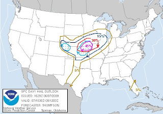
The SPC has upgraded the Kansas/Nebraska/Missouri area under a moderate risk for severe weather tonight through Sunday night. Take a look at the map below:


Here is the breakdown of the moderate risk area tonight and especially Sunday and Sunday night:

Tornadoes - 10%
Hail - 45%
High Wind - 30%

The thunderstorm activity will continue across northern Missouri tonight and possibly early Sunday morning. It should be dry across the area Sunday afternoon with highs on either side of 90 degrees. The chances for rain and thunderstorms increased toward the evening hours.

I will have a new blog tomorrow discussing the severe weather potential, but the ingredients are there for some tornadoes, damaging winds and very large hail. It will be an interesting day Sunday.

Alex Pickman

Saturday, June 6, 2009

Morning rain and thunderstorms

Good morning, and area of rain and thunderstorms is moving across the area. Take a look at the radar picture below:


There is no severe weather, but some of the storms are producing heavy rains very vivd cloud to ground lightning. All of the precipitation is moving off to the east, but what is causing it? Here is the current surface map:

There is a nearly stationary frontal boundary near the Missouri Iowa border that is allowing the showers and thundersotrms to move through. As you can see on the map above, there is a chance of severe weather in northwestern Missouri and much of Kansas. I think late tonight and tomorrow morning will hold much of the same with a complex of thunderstorms forming and then riding along the front and pushing through northern Missouri.
Areas who see the rain this morning will be a bit cooler than locations to the south who didnt get any rain. The areas that didnt get rain will see lots of sunshine, and warm SW winds, allowing temperatures to warm up into the 80's.
But overall this weekend should be pretty nice. I will have an update later today or tomorrow.
Alex Pickman

Thursday, June 4, 2009

Nice Friday

Well it was a great Thursday today with highs topping out in the 70's, light winds, and variably cloudy skies. Friday will be another near perfect day with upper 70's and low 80's around the area, partly cloudy skies, and winds out of the SSW at 5-15 mph.

A storm system is approaching around Sunday and there is a chance of a severe weather outbreak, but the models are showing a cap in place which a layer of warm air around 10,000 feet up which prevents thunderstorm development. If we are going to have severe weather, the cap needs to be a moderate level. If it is too weak, then we could get something like a morning squall line and thats it. If it is too strong, we will get nothing.

I am still working on a blog describing the cap, and I hope to have it ready tomorrow.

Alex Pickman

Quick morning update

Highs today will top out in the 70's all around the area with abundant sunshine. Friday will hold much of the same. It is going to warm up this weekend with some upp 80's and low 90's. Then here comes our next rain chance early next week, and we have a great setup for explosive thunderstorm development, but the models are showing a very strong cap forming and moving over the area. This is still several days away, and things will change, but I hope that the cap moves somewhere else since this is the best chance for severe weather we have had all year.

I will have more on the cap tonight.

Alex Pickman

Tuesday, June 2, 2009

Stormy Tuesday?...Updated!

A Severe Thunderstorm Watch has been issued for eastern Missouri and Illinois. Here is map of the watch are below:


As you can see on the map above, thunderstorms are firing and the are in the places I thought they would. The storms firing along the front are begining to take on training characteristics. Remember, dont drive on any flooded road ways and keep listening for any severe weather alerts. The storms are going to become much more numerous today.

Previous entry below:

------------------------------------------------------------

Showers and thunderstorms did continue last night as I expected, but they weakened significantly and this morning, there was nothin on radar, which is good If we are going to get thunderstorm development today. Take a look at the current surface map below. I have drawn in the very weak and almost stationary frontal boundary.


Temperatures along and south of the frontal boundary will be we into the 80's with 60's and 70's to the north. Also with dewpoints in the 60's to near 70 degrees in spots (look at the green numbers on the map above) Showers and thunderstorms are very likely. Where will they form? Well as you see on the map above I have them forming along the front. With winds aloft pretty weak around 10 to 15 mph, the chance of severe weather is slim, but the possibility of flooding increases as the storms will be moving very slow and likely training over the same locations.

The NWS has plaed nearly the entire area under a Flash Flood Watch. I see potential for raintotals exceeding 3 inches in spots who see the training storms. Now back to the severe weather potential. Take a look at the risk area below:


There is only a slight risk, but any one storm may become marginally severe. If any storms reach severe limits, the likley scenario will be maybe quarter sized hail 60 mph winds. The winds aloft are much to weak for tornado development. If you ar wanting to see tornadoes, go down to central Texas where there is a more favorable enviornment today.

I will have an update when storms start developing and if anything turn severe.

Alex Pickman

Evening Update

**FLOODING IS A BIG CONCEARN IN NORTHERN MISSOURI AS THERE HAS BEEN EXCESSIVE RAINFALL DUE TO TRAINING THUNDERSTORMS. ESTIMATED PRECIP SHOWS OVER 6 INCHES IN SOME LOCATIONS**

The showers and thunderstorms will continue in nothern Missouri and eastern Kansas, but should remain under severe limits. An outflow boundary from the storms that pushed through northern Missouri earlier today has moved southward, just north of Kansas City. Showers and thunderstorms are firing along and north of this boundary. I think they should remain where they are overnight, but what about tomorrow?

Well this boundary should become the new front, but I thinkit will be a little further north by morning than the current boundary. The conditions are all coming together for a wet and stormy Tuesday. I think heavy rains and flooding will be the biggest concearn, but I wouldnt rule out some severe weather. 1-2+ inches of rain may be possible in some locations. Highs tomorrow will be in the low to mid 80's, so another very warm day.

The cold front will be slowly saging south throughout the day Thuesday, and by Wednesday, the front will have passed through much of the area leaving up with a much cooler day with highs in the 60's. But the main storm sysem which moved out of Colorado will be moving out ahead of the front. This will create some showers, most likley in the morning.

After a pretty dry May, many lawns should get a decent drink. I will have an update tomorrow on the rainy start to the week.

Alex Pickman