Thursday, April 30, 2009

Morning thundrstorms

Good morning, An area of rain and thunderstorms has developed in Nebraska called an MCS. Out ahead of the MCS, the area leading thundersorms that formed and are pushing through the Kansas City area now. Take a look at the cureent radar image from 7:30 this morning;


These morning thunderstorms will create a problem this morning, especially near Kansas City. The MCS is also headed right for our area. Take a loook at the radar image from 7:45 of the MCS pushing southeast:


The big question is will they hold together and reach us? We will have to see, but I think they will. There is a slight chance of severe weather today with hail and high winds the primary threats. Take a at the severe weather risk are below:


A cold front is going to approach the area tonight, and we will likley see rain develop on the backside of it.

I will update the blog later this afteroon.

Alex Pickman

Wednesday, April 29, 2009

Rain tonight...wet week ahead!

Well, rain and thunderstorms have formed as expected over Kansas. It is pressing eastward across Missouri right now with some moderate to heavy rains, especialy around Columbia. Take a look at the radar image from around 9:30 PM:


There is no chance of severe weather with this rain tonight., but there could be some light flooding in the creeks with possily upto an inch of rain tonight in spots - mainly in central Missouri. Marshall, MO has reported close to an inch of rain tonight.

The rest of the night may have a few showers, but it most likely remain drizzly. Thursday may have some scattered showers and thunderstorms during the day with highs in the 70's to low 80's in spots. Take a look at the 500 mb map for Friday night:


By Friday night, a split flow will have developed with two jet streams. One jet to the north with a large ridge of high pressure and a trough to the east. The southern Jet streak is just to the south of our area. This setup is going to allow numerous upper level disturbences to roll through over the next week and bring us several rain chances.

After the rain tonight,and possible scattered showers tomorrow, the next chance of some steady rain will be on the back side of a strong first of May cold front. It looks like we will remain free of severe thunderstorms once again, but areas in southern Missouri, Kansas, and Oklahoma need to watch out again.

This strong cold front will drastically cool us down from what we have been experiencing. Highs Friday will be in the 50's in the morning with rain. Temperature will cool into the 40's by Friday afternoon with clearing skies.

Another disturbence will approach the area on Saturday, bring a cold rain to the area with highs only in the 40's. There is a chance of rain Sunday morning with highs topping out in the 50's. And it looks like a chance of rain Monday and Tuesday as well. So this is going to be a coold and wet weeks of weather, and flooding may be a concern at times with a chance of rain tonight through next Tuesday as the split flowis dominating the pattern this week.

I will have a new blog on the cold front tomorrow.

Alex Pickman

Wednesday morning update

Not muched has changed from my forecast last night. It still looks like 1 to 2 inches, possible 3 inches of rain over the next three days. I think the heaviest rain will fall across central Missouri, around Clinton to Columbia and south of there.

The NWS has issued a Flash Flood Watch for the area. Take a look at the map below:


The warm is still way to the south, and there is some rain and a few thunderstorms developing in southern Kansas. I think the rain should hold off in our area until late in the day and especially overnight. The chance for severe weather is slim, but the SPC does have our area on the edge of the severe weather risk. Take a look at the map below:

Winds will be out of more of an easterly direction ou ahead of the warm front. As the warm front pushes through, winds will change to the south and the winds will increase. I think highs will be in the upper 60's with a few 70 degree reading likely.
I will have a new blog laer this afternoon on tonight weather and Thursday interesting setup.
Alex Pickman

Tuesday, April 28, 2009

Warm front and T-storm chances

Lets take a look at the current surface map below:


Temperatures tonight re currently in the 50's. I do not expect temperatures to cool much further as clouds are spreading in from the southeast. Lows tonight should drop into the 40's and 50's around the area.

The clouds that are spreading in are creating a problem in forecasting the high temperatures for Wednesday. If it were sunny tomorrow, high would likely reach the 70's with the passage of a warm front that was once a cold front Sunday afternoon. Instead, I think we will be in the 60's primarily with a couple low 70 degree readings.

The warm front will begin to push through later in the day, drawing in gulf moisture. With moisture in place, the front will be the trigger for showers and thunderstorms to develop during the late afternoon and evening hours. There is a very slim chance for severe weather, with hail strong winds the primary threats. The bigger threat will be the possible flooding as the rain may be very heavy at times late Wednesday afternoon and overnight.

Rain and thunderstorms are likely Thursday morning, but I think we will see a break in the afternoon with highs in the 70's before a strong cold front pushes through. The front should push through during the evening on Thursday and I think this will be our best chance for severe weather with hail and straight line winds the main threats. Once the front passes through, the rain will end, but the rain and thunderstorms will be in the area through Friday morning. This could be another big rain producer.

There is potential for decent rains over the next three days. Rain totals Wednesday throguh Friday will likely range from 0.50" to 3.00". Right now it looks like the heaviest rain will fall over central Missouri.

The weather over the next three days is all associated with the same storm system. Here is a quick recap. The cold front through on Sunday will lift back to the north as the next storm system drags it up as a strong warm front. This warm front will trigger showers and thunderstorms, possibly heavy late Wednesday afternoon and overnight hours. We will see a break Thursday afternoon with highs in the 70's before a strong cold front pushes through, triggering more thunderstorms, and our best chance for severe weather. The chance is pretty slim, but the main threats will be hail and high winds. The rain will continue into Friday morning and it will be a cold rain with lows Friday morning likely in the upper 30's.
We may or may not get a break from the rain on Saturday. Some models have it wet, and some have it dry. It is really too far out to tell. I think Sunday will be dry, but it looks like our next storm will come Sunday night and Monday with another chance of rain ad thunderstorms.
I will have a new blog tomorrow afternoon.
Alex Pickman

Monday, April 27, 2009

Monday weather...Rainy week ahead

Sorry, I havnt had any time this weekend to post a new blog entry. Lets get right into what is going to happen today. A cold front is slowly sagging southeast, and with warm, moist air out ahead of it, showers and thunderstorms are likely. Some thunderstorms could be severe, with hail and high winds the main threat. There is a slight risk across central Missouri. I my opinion, the chance of severe weather is very slim. I think the primary threat will be flooding as these storms will be training over the same areas across central Missouri.

I think 1 to 4 inches will be possible if you are under training thunderstorms.

The rain will continue to slowly push southeast with the stalling cold front. I think the front will stall way in southeastern Missouri, and our next storm will approach us Wednesday. This will interact with the stationary front and draw it back north as a strong warm front on Wednesday. It will likely get muggy as the warm front will be drawing gulf moisture into the region. This moisture along with the rising motion, thunderstorms will be likely Wednesday. The storms will likely be heavy, and flooding will be a concern again. Severe may be possible again, but that may hold off untill Thursday or Thursday night as the strong cold front comes through.

So expect rain and thunderstorms today, Wednesday, Thursday, Friday, and maybe Sunday or Monday...We will only get a couple of breaks this week, so enjoy them while they last. Our first break will be tomorrow and maybe Saturday.

I will have a new blog tomorrow (Tuesday) afternoon.

Alex Pickman

Thursday, April 23, 2009

Evening update

We had a small, weak storm system move through the area this morning producing some rain and thunderstorms as it moved northeastward. It was creating problems with forecasted high temperatures today due to the cloud cover. The good news is that the sun came out as I expected, and temperatures warmed into the upper 70's to low to mid 80's.

Lows tonight will be in the upper 50's to lower 60's. The sun will be out tomorrow, and winds will be increasing from the south between 10 and 35 mph. This will allow temperatures Friday afternoon to top out in the low to mid 80's with a zero chance of rain.

Saturday is looking dry and partly cloudy with highs in the upper 70's to low 80's. There will be a cold front sagging south Saturday night and stalling near our area. It will waiver back and forth for the next few days, possible bring some heavy rains which may be excessive in some locations. It will all depend on how much the front shifts north or south. There will be a series of upper level disturbences riding along the front which will likely bring rounds of thunderstorms and heavy rains.

I would say, Sunday through Tuesday will potentially be very wet, but there is also potential to be on the low end of the amounts. I will have more on this later, lets just enjoy the warm air first.

Alex Pickman

Tuesday, April 21, 2009

Big warmup....wet weekend storm?

Well I havn't blogged for the past few days as we were in the transition phase between the cooler and warmer air. Today was the last of the "cooler" days with highs in the low 60's. Now we are about to enter a huge warm up. Take a look at the current 500 mb map below:


We are currently in what is called a northwest flow with a trough to our east. This weather pattern generally brings dry weather in the Winter, but during the Spring and Summer, this pattern can bring a wet solution due to the avalibility of moisture. The moisture is not avalible at this moment keeping it dry.

Look at the western United States with the red arrowns I drew in. This is signifying a ridge of high pressure and temperatures are going to warm up. The trough in the east is going to shift a bit further east everyday allowing the ridge to settle in right over us by Thursday and Friday. I think highs for Wednesday will generally be in the 70's with a couple 80 degree readings possible. Then the warmest of the air will come Thursday and Friday with highs in the upper 70's and low 80's across the area. One thing to note is that the lows will be in the upper 50's and low 60's.

Now take a look at the 500 mb forecast for Friday below:


We now have switched to a southwest flow as a trough of low pressure is forming into the west. This is going to create a setup for rain and thunderstorms Saturday night through Tuesday. A series of upper level disturbences will rotate around the main storm system bringing numerous chances of rain and thunderstorms. I am confident there will be some flooding in areas as the potential is there for very heavy rain and possibly severe thunderstorms.

This is still a few days away, so I will talk about the complex weekend system later.

Alex Pickman

Friday, April 17, 2009

Friday morning Update

Things havnt changed much since yesterday's blog, so expect highs today in the upper 60's to low 70's around the area with partly cloudy skies. Tomorrow should start off in the low 50's, and will rebound with highs in the 60's to possibly (if the sun comes out Saturday afternoon) on either end of 70 degrees.

Rain still looks good with a 100% chance between 6:00 AM and 12:00 PM Saturday, depending on your location. The band of showers and thunderstorms should be near Kansas City by 6:00 AM and pressing northeastward. The rain could be heavy at times, but should only last 1-3 hours as the band pushes to the northeast.

Skies may very well clear in western Missouri and eastern Kansas Saturday afternoon. If this happens, I think low 70's will be possible. Areas to the northeast and east of there will remain cloudy with showers, and thus remain in the 60's.

Another thing to note if the skies do clear to the west, there is a chance that - with enough moisture, there could be some thunderstorm redevelopment in the afternoon. I dont expect anything severe with this whole event in our area, the severe weather will remain to the south.

I am expecting a big warmup next week with quiet weather.

Take a look at yesterday's more in depth blog for more.

Alex Pickman

Thursday, April 16, 2009

Rainy weekend?...Severe Wx in south...Warm up!!

Sorry, I havnt posted a blog in a few days, but I have to make time to type this one as we have a very slow moving storm system approaching with rain likely this weekend. but before we get to that lets talk about what happened today, and what tomorrow holds.

We saw variably cloudy skies today with clouds ranging from partly cloudy to mostly cloudy. With the cloud cover, highs today remained in the 60's. If there was to be sunshine, then highs would of likely been in the 70's.

Friday will be similar with partly cloudy skies and highs in the upper 60's to lower 70's. the clouds and warm weather are associated with a storm system which is currently located around Utah and slowly pressing eastward. The system is causing some severe weather in Western Texas. Take a look at the severe weather map below:

There are several Tornado Warnings and Severe Thunderstorm Warnings. So what does this mean for our region?

The slow progression of the system will fortunately hold the rain off until early Saturday morning. This means a dry Friday. By 6:00 AM Saturday morning, I think there will be a band of showers and thunderstorms near Kansas City, pressing northeasterward. The rain could be heavy at times, but I dont expect any severe thunderstorms. The further northeast you are, the later the rain will arrive. Since I am covering a large area, I would say the rain will begin between 6 and 12 AM depending on your location.

For a better understanding here is a list of some cities and the time I think the rain may arrive on Saturday.

Kansas City - 6:30 AM
St. Joseph - 7:45 AM
Cameron - 8:00 AM
Chillicothe - 10:00 AM
Marceline - 11:00 AM

The good news is that the rain should'nt last a long time, only a couple hours at the most. There is even a chance that the sun may come out in western Missouri and eastern Kansas during the afternoon, and if that happens, temperatures will warm to near 70 degrees in spots. If there is enough moisture as well, the there could be some thunderstorm redevelopment, but once again I dont expect anything severe. Locations toward the east will see showers and clouds during the afternoon, and thus preventing the redevelopment of thunderstorms.

Now I bet you are wondering how much rain will fall? Well it is really hard to pon down, but I would say between 0.25" to maybe 1".

Once we get this storm passed us, there will be another storm near us on Sunday. Take look at the 500mb map below:
This storm could bring some showers, but the main thing is it will draw in some cooler air for Sunday and Monday with highs in the mid to upper 50's on Sunday and highs in the upper 40's to low 50's likely on Monday. Notice the ridge building in the west, well that is our next big warm up. Look at the map for next Saturday below:

This is looking to be the height of the warm up. Temperatures next Wednesday, Thursday, Friday, and Saturday should all be in the 70's and possibly 80's at times.
I will have a new blog tomorrow.
Alex Pickman

Monday, April 13, 2009

Cold, damp Monday...Good news!

Well it rained from Sunday afternoon through this morning as expected. Most locations saw 0.50" to 1:00" of rain. Now it is just cloudy, cold, and damp outside. Temperatures are in the low 40's in most locations and it wont warm up much more due to the cloud cover, north and northwest wind, and drizzly weather.

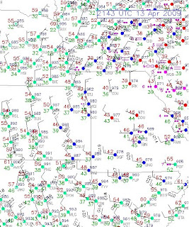
Lets take a look at the current surface map below:


We are gett that north to northwest wind on the backside of the storm system. This is wrapping in some cold drizzle and showers. Take a look at the current radar image:


These showers will likley continue this evening, but will end overnight as skies begin to clear.

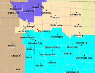
With calm winds, and clearing skies overnight, many locations will near or dip below the freezing mark. This wont be a hard, killer freeze, but some front is possible by tomorrow morning. In response to this the NWS has issued a Frost Advisory from areas around Kansas City southward. You can see the advisory in blue on the map below:


The good news is that once we get this cold day by us, abundant sunshine will return tomorrow and highs should warm into the upper 50's and low 60's. Actually highs will be very nice from Tuesday through Friday.

Look at the 500 mb map for Wednesday above. This is about 18,000 feet, or the middle layer of the atmosphere. We will be entering a ridging effect between two troughs. This will allow temperatures to warm up nicely. Wednesday through Firday all have potential to break 70 degrees in many locations. But the day I think it will be in the 70's in most locations is Thursday.
This great weather if you are waiting for morel mushrooms to begin popping. After all the recent wet weather, now we will get a 3, possibly 4 day break with highs in the 60's and 70's and lows in the 40's and 50's before another very slow moving storm enters the picture around Friday night and Saturday.
This next storm may have some thunderstorms, but it looks like severe weather is once again unlikely. Atlanta Georgia had an interesting weather phenomina this morning called a "Wake Low" It caused a 2 hour winds storm with 50 to 60+ mph winds that knocked out power in 220,000 households in Atlanta and 250,000 in Georgia.
I will dicuss the Wake Low later tonight and talk about the next storm this weekend.
Alex Pickman

Evening update!

This is a strong, slow moving storm system bringing our area a steady plain old rain with NO thunderstorms at all. Take a look at the current radar image below:

The rain, as shown by the arrow, is spinning clockwise around the storm. Add this with the slow movement, and rain totals around an inch plus will be common - especially if you get set under some moderate rain bands. I would say everyone will get 0.50" to 1.25" when all is said and done. The totals will be less near the Iowa border.

With the previous rainfalls, the ground is very saturated, and with this rain added on that, I am expecting some flooding problems. The NWS will likely issue a some kind of a flood statement later tonight.

The rain will continue into Monday morning. Take a look at the 850 mb temperatures below:

This is about 5000 feet above the surface. Temperatures at this level will be between 0 and -2 degrees celcius. As mentioned in the previous 2 blogs, some sleet may mix in with the rain in spots. The chance is small but the potential for some sleet is there.
How does it sleets when temperatures will be in the low to mid 40's at the surface? Well as the rain falls, it enters the cold air aloft (as you can see on the map above) and freezes into ice pellets. It then re-enters the warm air at the surface, but doesnt have time to melt and bounces on the ground as sleet.
The rain should end around noon Monday, but a few lingering showers are likely.
We will get a break until around Friday when the next storm is due. If you are hoping for a warm and sunny day, look for Thursday. Highs Thursday may make it into the low 70's.
I will have another blog tomorrow.
Alex Pickman

Sunday, April 12, 2009

Wet Easter afternoon

An an area of steady light to moderate rain is slowly pushing north. Take a look at the radar image below:


If you are in southern Missouri, then it is likely raining now, but if you live in places from I-70 northward then as mention in the previous blog, the steady rain wont arrive till the afternoon and overnight hours. I would say between noon and 2 PM in Kansas City, and later the further north and east you live.

I just talked about when I expect the steady rain to start falling. There is still a chance of some rain showers developing before then, but they will be light in nature.

Im still not sure if there will be any sleet mixing into the rain on Monday, but a few pellets may make it to the ground Monday morning. Again, the chance is very slim. I am still thinking a decent rainfall of 0.50" to 1.25" with locally higher amounts up to 1.50" to 1.75" are possible through Monday.

I will have a new blog tomorrow.

Alex Pickman

Saturday, April 11, 2009

Wet Easter?

Sorry about not getting in any posts, I was having trouble with my account but the problem is resolved now. So I missed talking about 1 wet storm Thrusday night and Friday morning, but just in time for a wet Easter storm.

Another strong storm will enter the area and we will begin to feel the effects sometime tomorrow morning as rain begins to move in. This is right on the heels of the Thursday night/Friday morning storm giving us only one full dry day before we get another dumping of rain tomorrow.
Now when will the rain begin? The data is trending toward an earlier start to the rain..I would say between 9:00 AM and 11:00 AM, some showers will move in. The further northeast you live, the longer the rain will hold off. These will be light and the heavier rain wont move in till the late afternoon and overnight hours. The rain should continue into Monday morning.

Highs Sunday will likely make it into the low 50's before the winds pick up, rain arrives, and temperatures fall back into the 40's. Lows Monday morning will be in the upper 30's and low 40's with a steady rain, and likely only climb into the low to mid 40's Monday afternoon. With surface temperatures in the 40's, you would think this would be an all rain event, but there will be some cold air aloft Monday.
Here is the surface temperature map for Monday:

I think a few sleet pellets are possible mixed in with the rain. How can there be sleet pellets with surface temperatures in the 40's? Well when the rain falls and there is a cold layer of air aloft, it enters the cold air aloft and freezes into small ice pellets. It then re-enters the warm air near the surface, but doesnt have time to melt and bounces on the ground as sleet.

So dont be surprised Monday if you see a few peices of ice bouncing on the ground. The chance for sleet is pretty slim, but the potential is there for some to reach the ground.
The rain should end in the late morning hours on Monday. So how much will fall? Here is what the GFS is showing for accumulated precipitation through Monday:


I would say when the rain is done that most locations will likely see between 0.50" and 1.25". There will likely be some locally higher accumulations, but we will have to see where the heaviest rain sets up. Now with the ground already saturated, and streams high, flooding is likely as the soil and streams cant take it.

If you are wondering about severe weather, this will not be the event for area once again as the storm is tracking too far south. Here is the severe risk area for Sunday:

There is already a Severe Thunderstorm Watch with thunderstorms lining up in eastern Texas. Damaging winds, large hail, and tornadoes are all possible in the south tomorrow. Southern Louisiana needs to watch out for hail and tornadoes especially.
So expect ome showers to work in between 9 and 11 Sunday morning from the south and west. The steady rain wont arrive until later in the afternoon through Monday morning. Some sleet may mix in Monday morning if the conditions are right. No snow is possible with this storm. There wont be any severe weather in our area, but the will likely be some significant severe weather in the southern states with large hail, dmaging winds, and some torndoes the main threats. Flooding is a strong possibility with an already saturated ground, and 0.50 to 1.25" on top of that.
The good news is that we should get a 2, possibly 3 day break from the rain before anothe storm arrives around Friday.
I will have a new blog Sunday morning.
Alex Pickman

Sunday, April 5, 2009

Cold blast...some snow?

Dont expect any accumulation today. Just cold and winds with some rain and snow.

-----------------------------------------------------------------

This is a very complex and interesting storm system affecting us. Yesterday, we were in the warm sector with winds 20 to 40 mph. This created the setup for some thunderstorms to form durng the evening hours. The storm had some lightning and heavy rain with them, but the ingredients were not there for severe weather.
This morning was not bad with temperatures still in the 40's, but they have begun to drop into the 30's now and will continue throughout the day. Lets take a look at the current surface map below:

There is cold air and strong winds blasting in behind the cold front. Oklahoma City is reporting sustained winds of 36 mph, gusting to 44 mph.

The inverted trough extending northwest from the surface low will swing trough later and the winds will increase with the chance of some snow showers. I think there will be some accumulation, but it is hard to put a number on, so would say if you live north of I-70, a dusting to 2 inches is possible with higher totals occuring the further north you go. There is a Winter Weather Advisory in effect in northwest Missouri.
Now I havnt really talked about this much, but it is going o be very cold Monday and Tuesday morning. Take a look at the warning map below:

You can see the Winter Weather Advisory in northwest Missouri, but what is that light blue color? That is a Freeze Warning...As you can see it is south of Highway 36, but the entire area in that map above will see a hard freeze with temperatures in the low to mid 20's Monday morning, and even cold Tuesday morning with temperatures in the upper teens and low 20's. So plants need to be covered up.

There is another storm showing up Thursday. Here is the 18z GFS forecast valid Thursday:

I will have an update later.
Alex Pickman
Saturday, April 4, 2009

Saturday night update

Some thunderstorms have formed and are pressing northeastward. There will likely be some heavy rain and some wind with the storms, and I wouldnt rule out some small hail of pea sized. Take a look at the radar image below:


These are very fast moving storms and rain totals may reach 0.25" The cold front will push through early tomorrow morning, and there is a chance for rain and snow in the morning with temperatures in the 40's.

Temperatures will fall throughout the day and the precipitation will likely change to all snow. There could be some accumulation, but the chances increase the further north you are. I would say maybe up to 3 inches right near the Iowa border, but that is probably an exagerrated estimation.

I will have a new blog tomorrow.

Alex Pickman

Very interesting storm

We have strong southerly winds out ahead of a storm that will affect us later this afternoon and overnight and Sunday. Winds are blowing out of the south at 10-35 mph and this will continue into Sunday. Take a look at the surface map below:


There are some showers possible this afternoon, but the beter chance of rain and thunderstorms doesnt come until this evening. A line of showers and thuderstorms is likely to form and push through the area this evening. But with a cooler system and limited moisture, the storms should stay below severe limits. I wouldnt rule out 1 or 2 storm reaching marginally severe limits.

This will be a thin, fast moving line, so rain totals will not be high at all - maybe up to 3 tenths of an inch The the cold front will move through later tonight and by Sunday morning temperatures will be in the 40's with a chance of some rain and snow, then as temperatures drop during the day, it turns to all snow and there could be some accumulation in northern Missouri, possible over an inch or more.

Be carefull today if you traveling to Nebraska as a big late season blizzard is ravaging the state with strong winds an up to a foot or more of snow!

Alex Pickman