Saturday, May 29, 2010

2010 Hurricane Season

Well its that time of year again with only a few more days until the start of Hurricane season in the Atlantic which runs from June 1st through November 30th. Every year before the season begins, a team of researchers of the Colorado State University analyze data and produce an outlook for the number of tropical systems possibly to develop in the Atlantic. Back in April, 2010, this team of researchers predicted an above average year with around 15 named storms and possibly 4 major (Cat 3, 4, 5) hurricanes. The outlook was recently revised, but not for the better. This most recent outlook increased to an eye opening 14 to 23 named systems. This is way up from from the previous 15 storms which was already above average. With the increase in the number of storms, there is an increase in the number or hurricanes and the number of major hurricanes. So here is a quick breakdown of the 2010 Hurrican season:

Named Storms: 14-23; Number of Hurricanes: 8-14; Major Hurricanes: 3-7

So, why is this season expected to be such an active one? There are several factors that are included, but here are the biggest ones. The surface temperatures of the Caribbean and the Tropical Atlantic are exceptionally warm which will provide the fuel the storms need. Neutral or La Nina conditions are developing in the Tropical Pacific with La Nina becomeing more an more likely. Computer models are also showing a vast number of storms developing and is as well predicting an extremely active season. There have been some extremely active seasons in the past and many of those season had a similar oceanic setup to this seasons’s. Remember, the average number of named storms is 11, with around 6 hurricanes, and two of which becoming major of Category 3 or higher. If this season ends up at the high end of the predicted number of storms, then it will go down as one of the most active seasons on record.

With so many tropical systems being predicted, there is increase of U.S. landfall. Anyone who lives along the coast from the Gulf of Mexico, all the way up the east coast needs to be prepared. It is impossible to predict how many storms will make landfall as that lies with atmospheric conditions, but you should have the mindset going into a season that any storms that form pose a threat.

I am worried about the huge oil slick in the Gulf of Mexico just south of Louisiana and Mississippi. Remeber Hurricane Katrina from 2005, which was the most active season on record. Look at the picture below:


Hurricane Katrina, a strong Category 5 hurricane is passing through the current location of the oil slick. If a hurricane decides to take a similar path this season, all of the works and hopes to keep as much oil out of the marshes will be lost. With the oil leak the biggest disaster in years, the last thing we need is a hurricane to track over it as it will create a natural disaster of epic proportions.


Many ingredients need to come together from water temperatures to atmospheric conditions, but this season may be one to be remembered.

Alex Pickman

Wednesday, May 26, 2010

Thunderstorms Wednesday

Thunderstorms developed across eastern Kansas and Missouri today (Tuesday) with the heating of the day. Some of these thunderstorms reached severe limits and produced some hail. Ping pong sized hail was reported just east of Smithville, MO. Since these thunderstorms were being powered by the heat, once the evening approached, they began to die. The bigger threat with these thunderstorms today was the heavy rain. There was just about no wind shear, so the storms were moving very very slowly and flash flooding was a concearn.

The thunderstorms this afternoon were scattered, but they will be more numerous for Wednesday from Kansas through Missouri and northeastward into Iowa, Illinois, and southern Wisconson. The storms will be developing along the frontal boundary and the thunderstorms will likely not get into anything very organized, but some organizations is possible at time throughout the afternoon and into the evening hours. There is a very slight threat of some of the thunderstorms turning severe, but some of these storms will “pulse” up during the afternoon and become strong to severe with hail the main threat.

The thunderstorm threat will diminish by Thursday across the southern Plains and lead to a very pleasent Memorial Day weekend with high temperatures in the 80’s throughout the region.

Alex Pickman

Saturday, May 22, 2010

Big Warming Trend!

It has been a very cool and wet may across eastern Kansas and the norhern half of Missouri with the past 16 days having below average temperatures. Today this streak of cool weather was ended. Take a look at the GFS 500 mb map this afternoon below:

We are experiencing ridging over the Plains which is allowing very warm air to spill into the region. The troughing over the west is keeping the cooler and active weather away from us and will remain in place through next week. Temperatures this afternoon will warm into the mid to upper 80's with dewpoints in the upper 60's and low 70's, creating very humid conditions with all of the recent rains.

There may be some pop up showers across northern Kansas and Missouri, but they should diminish by noon. There will likely be a slight chance of an aftrnoon pop up shower or thunderstorm everyday through this next week.

Alex Pickman

Wednesday, May 19, 2010

Late afternoon update

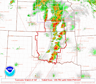
Thunderstorms are firing across central Oklahoma and rapidly growing in strength. Take a look at the current PDS Tornado Watch below:

Here is the current severe weather report map below:

There have already been 13 tornado reports and there will be more to come with the possibility of large tornadoes forming. The severe and tornadic threat will continue into the overnight hours and this will make for a dangerous situation as tornadoes are hard to see at night and most people are asleep. These intense supercells are also containing very large hail and damaging winds.

This event is just starting ramp up so stay tuned to your weather radio and the NWS (National Weather Service) for the latest warnings.

Alex Pickman

Heavy rains expected

A slow moving storm system is begining to affect the area late this morning. The NWS (National Weather Service) has issued a Flood Watch for eastern Kansas and western and central Missouri with a Flash Flood Watch to the south of that. Take a look at the warning map below:
This is in expectaion of heavy rains this afternoon and especially overnight. Our first round of weather is a slow moving band of steady rain currently moving out of Kansas and into western Missouri. The areas where it is currently raining will likely remain in the upper 50's for highs today continuing the now 2 week stretch of cool temperatures. This area of rain will slowly press northeast and stick with us through the afternoon. This first round of precipitation is associated with a warm front in Oklahoma. Take a look at the surface map below where I have drawn in the fronts:

The surface low will push east into Oklahoma and conditions will be favorable for severe thunderstorms to develop with another major outbreak likely across the same locations as the May 10th outbreak last Monday. The SPC has issued a High Risk for central Oklahoma. Take a look at the Risk map below:

Thunderstorms will form along the dryline and rapidliy become supercellular. There will likely be numerous tornadoes and a few of them may be quite strong. Remember, last Monday, there were 2 EF-4 tornadoes that tracked through the southern Oklahoma City area affecting the towns of Moore and Norman, OK. This could be a scenario again today, so people need to pay close attention to any warnings issued. Along with the tornadic threat, the stronger cells will likely contain hail up to baseball+ and damaging winds. The severe threat will shift into eastern Oklahoma this evening and possibly evolve into a MCS (Mesoscale Convective System) and track into Missouri. This will be our second round of rain and will likely be heavy.

There really isnt a severe thunderstorm threat in Missouri today or tonight, but 1-2 inches of rain will fall and there could be localized areas of 4+ inches leading to flooding.
I will have a new entry late tonight.

Alex Pickman

Late night update

A severe weather outbreak is likely Wednesday afternoon across Oklahoma with tornadoes, very large hail, and damaging winds. The severe threat will shift into eastern Oklahoma Wednesday evening and the precipitation may form into an MSC (Mesoscale Convective System) and track northeast into Missouri where a flooding threat may occur with heavy rainfall.

I will have a new entry in the morning with the latest developments.

Alex Pickman

Saturday, May 15, 2010

Rain exiting...more to come

An area of rain expanded in coverage across eastern Kansas and Missouri this morning and lingered around all day. Totals were not impressive with around half an inch to areas just to the southwest of Kansas City. The southern extent of the rain is currently in northern and north central Missouri and most areas will remain dry overnight, but there could be some drizzle and scattered showers.

A disturbence in eastern Oklahoma will cause another area of rain to develop to the south and west in southern Missouri and Kansas that will lift north and east. Rain totals will generally be less than half an inch, with southwestern Missouri maybe with closer to an inch of rain. The morning may be the only dry hours for most locations tomorrow. Highsfor your Sunday will be in the mid to upper 50's from Kansas City northward with low to mid 60's to the south.

Alex Pickman

Thursday, May 13, 2010

2:00 AM update

**Damage reperted in Kansas City metro area from straight line winds**

Rain and heavy thunderstorms are moving from southern Kansas northeast through southeastern Iowa. They are riding northeast along a frontal boundary associated with a very slow moving storm system. Take a look at the map below where I have drawn in the fronts:


The SPC still has the area under a slight risk for severe thunderstorms with damaging winds being the main threats. The biggest threat with this system is the very heavy rainfall. With the the slow progression of the storm and frontal boundaries and the heavy precipitaion riding northeast along it,  a training effect is occurring. This is leading to excessive rainfall from southeast Kansas northeastward through Missouri. There may be localized areas with over 3 inches of rain tonight. There are many Flood Watches and Warning currently across Missouri due the rain tongiht on the already saturated ground.

By Thursday, the rain and thunderstorms should shift from Illinois southwest through Arkansas. With all of the rain recently, you probably dont want to hear about another wet storm sytem for this weekend.

I will have an update Thursday morning.

Alex Pickman

Wednesday, May 12, 2010

Late afternoon update

Thunderstorms have fired across parts of Kansas, Oklahoma, and Missouri. As I mentioned in the last entry, I was expecting to thunderstorms to fire along the cold front in a scattered line from south central Kansas southwest through west central Oklahoma, and this is what happened. There is another cluster in north central Kansas and a cluster that just developed recently in west central Missouri. The NWS has issued a large Tornado Watch from nortern Texas northeast to just south and west of Kansas City. Take a look at the map below:


As you can see in the map above there is another small Tornado Watch just to right of the Kansas watch. This small watch box includes the Kansas City metro area. Thunderstorms will likely continue to develop in eastern Kansas out ahead of the main line with hail the main threat in any severe thunderstorms. There is a small chance an isolated tonado may spin up, but it really isnt worth mentioning, just that there is a small risk for a tornado. The best chance for a tornado will liekly be in western Oklahoma and south central Kasnas.

The biggest threat from this system is looking like the flooding potential. Moisture is streaming in from the southwest and with heavy thunderstorms along a slow moving cold front, flooding rains are likely in spots, especially in far eastern Kansas and through Missouri where nearly the entire state is under a Flood Watch.  

The cold front will slowly slide into Missouri tonight with heavy thunderstorms in a line along it. The storms, some strong or severe will ride along the front, moving northeast and training over the same areas. Some spots will see excessive rainfall from this. This system has the potential to produce much more that what it is now, but there are limiting factors and I mentioned one in the last blog.

Large hail looks to be the main threat from thunderstorms through the overnight hours with excessive rainfall the main threat with a "training" nature of the storms. I will have an update around 1 AM.

Alex Pickman 

Strong storms today?

A warm front is lifting northward through Kansas and Missouri. Take a look at the surface map below where I have drawn in the front:

Temperatures south of the warm front are in the mid to upper 70's and will likely may a run into the low 80's. The front is having trouble pushing northward due to cloud cover. Take a look at the current visible satelite image below:

You can clearly tell where the front is loated by the clearing line from Kansas through central Missouri. If the cloud cover just to the north can break up a bit, the front will be able to push north faster and allow temperatures to heat up faster. I do think the front will still stall across northern Missouri this afternoon, but the timing is uncertain due to the cloud cover. Southern Missouri and Kansas will not have a problem heating up this afternoon as the front is well to the north. Northeastern Kansas and northern Missouri is a very difficult and complex forecast. Temperatures near the warm front this afternoon will be limited to the low to 70's from near Highway 36, and get cooler northward causing the air to be much more stable.

South of the front, temperatures will warm up to near 80 degrees and dewpoints will surge into the 70's, so any thunderstorms that do develop will have plenty of energy to feed off of. Mid Level CAPE values will also be between 3000 and 4000 J/KG, which will aid in severe thunderstorm developent. One limiting factor is a strong cap (warm layer aloft) moving northeast of the area. This will prevent any development for most of the day until it weakens later in the afternoon. Once it weakens and breaks, thunderstorms should begin to fire along the cold front in a scattered line in south central Kansas and northen Oklahoma. With effective wind shear near 50 KT, a few supercells may develop and track northeast into eastern Kansas. These supercells will have strong winds and very large hail, and possibly pose a tornadic threat especially in south central and eastern Kansas.

The area of rain and thunderstorms will expand in coverage as it slowly moves along the cold front into western Missouri. Damaging winds and large will likely be the main threat with any severe thunderstorms. With the slow advance of the front, heavy rain is expected along with the strong thunderstorm potential this afternoon and especially overnight. The ground is already saturated from the recent rain, and as a result, the NWS has put a most of Missouri under a Flash Flood Watch.

I can see several other possible scenarios developing this afternoon and overnight, and I am not not sold on this forecast. This is a very complex system and a lot of things can still change. This is going to likely be a "Nowcasting" event. I will have an update around 6 or 7 this afternoon with the latest information and update the forecast as needed.

Alex Pickman

Late night thoughts

The frontal boundary that was stalled in Oklahoma has begun to surge northward. Take a look at the surface map below where I have drawn in the warm front.


The front has now pushed into southrn Kansas and Missouri and has set off showers and thunderstorms. Here is the current regional radar image:


The thunderstorms are forming along the warm front are slowly progressing northward. Notice how heavy the thunderstorms are over Missouri. They are growing in strength and coverage and are not moving much at all, moving over the same locations. This is creating a flodding problem. Also to add to that some of the thunderstorms have reached severe limits and are prducing hail and strong winds. The SPC has much of the area under a slight risk tonight tonight through Wednesday night. Take a look at the risk map:

There is currently no watches in affect for Missouri, but a large Severe Thunderstorm Watch is in affect for the southern half of Kansas. The thunderstorm threat will continue to psh northward through the overnight hours and Wednesday morning. By Wednesday afternoon, the warm front will likely be stalle over northeast Kasnas and northern Missouri. Temperatures south of the front will likey make a run into the lower to mid 80's with dewpoint possibly surging over the 70 degree mark. A cold front will approach the area Wednesday afternoon and with a arm and very moist airmass in place, thunderstorms will be a likely result. The SPC has much uf the area under a slight risk for severe thunderstorms for Wednesday afternoon as you can see below:

As mentioned above, we are dealing with a very warm and humid airmass behind the warm front. There are also other factors initiating the potential thunderstorms Wednesday afternoon. Mid Level CAPE value will surge between 3000 and 4000 J/KG. The warm sector, which is the area behind the warm front and ahead of the cold front, will be capped during the day Wednesday, but by late afternoon, several thunderstorms should begin to erupt in a scattered line from northern Missouri and southwest through eastern Kansas. This area, where the intial development will likely be, will be favorable for supercell thunderstorms to form due to strong wind shear. This may lead to isolated tornadoes.

Any thunderstorms that do form in this vicinity will have to be monitored closley as they may very quickly become supercellular and begin to rotate. Very large hail will also be a threat from these thunderstorms.

So overall, expect rain and thunderstorms to push northward overnight and tomorrow morning along the progressing warm front Some of these storms may be strong to severe with hail being the main threat. The front will stall over northern Missouri. Warm and very humid air will surge in behind the front and atmospheric conditions will be favorable for sevre thunderstorm development Wednesday afternoon as a cold front approaches the area. Initial development of thunderstorms will likely be from northern Missouri southwestward through eastern Kansas. Isolated Tornadic supercell thunderstorms may quickly develop in this initial development.

I will have an update tomorrow morning. This will likely be an active day.

Alex Pickman

Tuesday, May 11, 2010

Thunderstorms tonight and Wednesday

After the tornado outbreak in Oklahoma yesterday, another storm system is going to affect our area beginning tonight. A cold front is currently stalled over Oklahoma and will being pushing back to the north as a warm front later tonight. As it does so, it will spark off showers and thunderstorms. The air to south of the front is warm and very humid, and this will feed thunderstorm development tonight.

There will likely be a few severe thunderstorms along the warm front with the biggest threat being large hail. The SPC has much of the southern Plains under a slight risk for severe thunderstorms tonight.

Oklahoma has the biggest risk for severe thunderstorm development again, especially over western and north central Oklahoma. The atmosphere there is favorable for isolated thunderstorm development and large hail and strong winds will be the biggest threat, but an isolated tornado cannot be ruled out.

The warm front will continue pushing northward throughout the night and by Wednesday afternoon, the front will likely be draped over northeast Kansas and northern Missouri. Showers and thunderstorms, some strong to severe will be likely along it. Take a look a look at the the severe thunderstorm risk map for Wednesday:

This is a very complex forecast Wednesday and I will discuss it more later tonight.

SO for the rest of this afternoon and overnight, expect rain and thunderstorms to begin developing from Oklahoma into Arkansas along the warm front. Some of these storms will be strong to severe and gradually push northward overnight. By late tonight and Wednesday morning, the rain and thunderstorms will likely be located along the I-70 corridor affecting locations from Cenral Kasnas,through estern Missouri.

I will have a new blog and go into more details on Wednesday's difficult forecast later tonight around 1:00 AM.

Alex Pickman

5-10-2010 Severe Weather Outbreak

It was an extremely active day across the southern Plains with numerous severe weather reports as an intense storm system sparked off numerous strong supercell thunderstorms that produced huge hail, damaging winds, and tornadoes. Here is the map from The Storm Prediction Center showing the severe weather reports:

There were 37 reports of tornadoes across southern Kansas and Oklahoma and with those tornadoes unfortuneately 5 deaths were reported. The Oklahoma City area was hit by a couple tornadoes. Three storms blew up on the west side of the city and turned into a tornadic supercells in no time at all. The storms raced ENE at nearly 55 mph and produced a tornado that tracked through south OKC, Norman, and Moore, OK. Here is a radar image of the same storm roughly 60 miles to the east right near the town of Siminole, OK.


This is a classic looking supercell, notice how well defined the hook is.

Now if you look back up to the report map, notice how localized the outbreak was, from south central Kansas through southern Oklahoma. This storm system had the potential to produce a historic severe weather outbreak, and we would of been dealing with reports across Arkansas, and Missouri as well, but that area was dealing with cloud cover, rain, and a cold airmass all day and this pretty much fizzled away the chance of severe weather.

There is a chance for more thunderstorms Tuesday evening and overnight as a warm front lifts northward through the area. There is a chance a few storms may be severe, but my focus is Wednesday afternoon and evening. The warm front will be pushing into northeastern Kansas and northern Missouri and the focus will be on locations south of the front where storms will likely fire. I will go into more detail on this tomorrow and in the next couple days I will post the tornado ratings from Monday's tornadic event.

Alex Pickman

Monday, May 10, 2010

7:00 PM Update....Storms raging!

Thunderstorms have vigorously formed along the dryline in Kansas and Oklahoma where expected. There are currently 4 Tornado Watches issued across the southern Plains, but I want to fucus right now on th PDS (Particurally Dangerous Situation) Watch box. This watch extends from southern Kansas through Oklahoma. Take a look at the map below:


As you can see, the length of the Watch is lined with thunderstorms, and these storms are huge. As of right now, there have been 21 tornado reports, and there will likely be many more to come. There was just recently a tornado ripping through the southern Oklahoma City area and effecting highly populated areas including Norman and Moore, OK. This storm is now located east east of Okalahoma City racing ENE at 55 mph. Take a look at the current and impresive radar image of the is strong supercell below:


This storm means business and anyone in its path should take shelter immediately! The storm has had a history of tornadoes including ripping through OKC, damaging winds, and huge hail of baseball and up. Based on the radar image above, the storm looks to have possibly a large tornado on the ground so please seek shelter if you are in the path of this storm.
 
Here is a map of all the curent Severe Weather Watches:
 
This is an extremely dangerous event and should not be taken lightly. I wont have another update till around 1:00 AM, but there will still be storms rumbling then too.

Alex Pickman

UPDATE...PDS Tornado Watch!

Thunderstorms have already started to fire in western Kansas and Oklahoma! The NWS has iss ed two Tornado Watch. Here is the first Watch below in western Kansas:

And now here is the second Tornado Watch for southern Kasnas and Oklahoma. This is a PDS (Particurally Dangerous Situation) Watch and people need to take extreme caution as this outbreak is beginning to unfold!

I will have a new entry around 5:30 PM. Until then likely expect the thunderstorms to fire and QUICKLY turn severe and more Watch/Warning to be issued!

Alex Pickman

High Risk!

Conditions are set in place for a severe weather outbreak across portions of the southern plains. Take a look at the severe thunderstorm risk map issued by the SPC below:

The SPC has issued a High Risk for far southeast Kansas and north central/northeast Oklahoma with the threat of large, long lived tornadoes. A potent surface low is continuing to develop and track into southwest Kansas with a 993 mb reading. Behind the warm front, strong southerly winds are allowing moisture form the Gulf of Mexico to surge in with dewpoints will into the 60's ahead of the dryline. Take a look at the surface map below:

You can see the surge of warm, moist air between the front an the dryline. As this moves eastward, thunderstorms should begin to develop along the dryline in south west Kansas and west central Oklahoma. Notice the cool air over Missouri and northeast Kansas. This is being caused by the rain and thunderstorms currently pushing though and will limit most of the tornadic potential later tonight as the storms move that way. The High Risk and surrounding areas are currently dealing with a low cloud problem as you can see in the map below:

If this were to remain in place, it would greatly limit th severe potential of this system, but the low cloud deck is gradually burning off from west to east and will set the stage for quite an outbreak of tornadoes.

The cap should gradually weaken throughout the afternoon and once it breaks, the storms will begin to erupt and as mentioned above, im thinking south west Kansas, and west central, Oklahoma, right near the triple location. With very effective wind shear in place of 50-80 KT and good vertical shear, warm, moist air, Mid level CAPE over 3000 J/KG, the thunderstorms should very quickly become supercellular and race to the northeast with every storm having the potential for extremely large hail, damaging winds, and large, long lived tornadoes. This is for the High Risk area in KS and OK. What is expected for areas to the northeast toward Kansas City today and tonight?

The powerful surface low is associated with a negatively tilted potent upper level low that will be located in across eastern Kansas later tonight around 10:00 PM. With the negatively tilted nature of this storm system, the atmosphere has much more lift to it and the storms will be able to keep on going even though they will be entering a cooler enviornment as you can see in surface map above. Now, the tornadic risk will be greatly reduced and will be limited to SE Kansas, NC/NE Oklahoma, and possibly SW Missouri, but there is still a decent chance for severe thunderstorms in the form of large hail and damaging winds. The storms KS and OK will move our way overnight and evolve into more of a cluster of strong to severe thunderstorms and push through the area later tonight.

This is a very complex forecast and I will have a new entry later this afternoon with the lastest information and the possibility fo more strong thunderstorms on Wednesday.

Alex Pickman  

Sunday, May 9, 2010

Monumental Severe Outbreak Likely!

A significant severe weather outbreak, which has been very well advertised for the past week is now bearing down on the southern Plains. The SPC has issued a Moderate risk for parts of central Kansas, into central Oklahoma, and southwestern Missouri. Here is the risk area below:


A warm front is currently pushing northward and is setting off numerous showers and thunderstorms across southern Missouri that will contimue to expand in coverage and intensity overnight and Monday morning. As the thunderstorms push northward Monday overnight and Monday morning, some large hail and heavy rain may result, especially in the stronger cells. These storm will likely extend from Nebraska and eastern Kansas, into Missouri and Arkansas. This is not the main show however. 

Computer models continue to show all the sufficient parameters for an intense day of severe thunderstorms. Once the warm front lifts through the area, dewpoints of 60+ degrees will establish out ahead of the dryline from north Texas into Kansas. There was concearn earlier this past week that the cap would be too strong and limit development to overnight or none at all, but that should not be the case with this storm system.The cap should erode through the mid and late afternoon Monday and thunderstorms should begin to fire across part of central Kansas by the mid afternoon hours. With the dryline, CAPE values between 2000-3500 J/KG, outrageous wind shear of 60-90 KT, and all the other parameters in place, Extremely dangerous, fast moving supercells will likely result across parst of Kansas and Oklahoma. These storms will be capaable of producing incredible hail and dangerous large, long lived tornadoes. As the storms move eastward through the evening and overnight hours, the nature of them will likely become more linear and clustered and maybe (MCS) like with large hail, damaging straight line winds, and still a tornadic threat. 

This is looking to be a historic day! I will have a new entry tomorrow morning and we should have the Plains first High Risk of the season!

Alex Pickman