More rain tonight
Today will remain cloudy with highs in the upper 70's to low 80's around the area. There is band of rain stretching northward through central Kansas, and some showers and maybe a thunderstorm will be possible by late this afternoon based on the current radar trends.
The National Weather Service has locations along and north of I-70 in a Flash Flood Watch.
This Flash Flood Watch is in antisipation of possibly some very heavy rain as a strong cold front meets up with a plume of tropical moisture from Mexico. 1-2 inches of rain may fall across parts of northern Missouri tonight as rounds of thunderstorms move through the area. The ground in this area is saturated from recent rounds of heavy rain and thunderstorms, so more flash flooding looks likely. With MLCAPE of 500-750 J/kg, the risk for severe thunderstorms is pretty low as the atmosphere may be too stable, but a few isolated strong to severe thunderstorms may develop. The main risk would be some gusty winds and marginally severe hail.
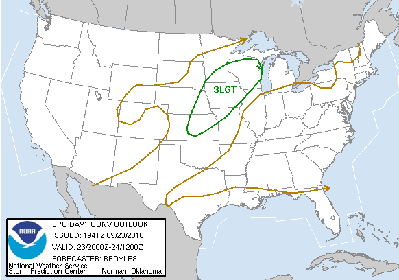
As a result the Storm Prediction Center has a slight risk for severe thunderstorms from Kansas, northeast through Iowa and Michigan.
Late tonight the strong cold front will sweep through with a long line of thunderstorms. They should be under severe limits, but a few parts of the line may produce winds gusty enough to become severe. The rain chance should be completely out of the area by Friday morning.
Friday should be great with temperatures in the low to mid 70's and no rain. The forecast gets tricky Saturday into Sunday as an upper level low becomes "cut off" and moves south over us Saturday night. The computer models are not consistant on where it will end up tracking, but it looks like it will either be cool and dry, or cool and wet. It will take a couple more days to figure this out. This would definitely be a cool and wet scenario.

Alex Pickman
The National Weather Service has locations along and north of I-70 in a Flash Flood Watch.
This Flash Flood Watch is in antisipation of possibly some very heavy rain as a strong cold front meets up with a plume of tropical moisture from Mexico. 1-2 inches of rain may fall across parts of northern Missouri tonight as rounds of thunderstorms move through the area. The ground in this area is saturated from recent rounds of heavy rain and thunderstorms, so more flash flooding looks likely. With MLCAPE of 500-750 J/kg, the risk for severe thunderstorms is pretty low as the atmosphere may be too stable, but a few isolated strong to severe thunderstorms may develop. The main risk would be some gusty winds and marginally severe hail.
As a result the Storm Prediction Center has a slight risk for severe thunderstorms from Kansas, northeast through Iowa and Michigan.
Late tonight the strong cold front will sweep through with a long line of thunderstorms. They should be under severe limits, but a few parts of the line may produce winds gusty enough to become severe. The rain chance should be completely out of the area by Friday morning.
Friday should be great with temperatures in the low to mid 70's and no rain. The forecast gets tricky Saturday into Sunday as an upper level low becomes "cut off" and moves south over us Saturday night. The computer models are not consistant on where it will end up tracking, but it looks like it will either be cool and dry, or cool and wet. It will take a couple more days to figure this out. This would definitely be a cool and wet scenario.
Alex Pickman
posted by AlexPickman at
11:38 AM
0 Comments
![]()


