Sunday severe risks...updated!
A Tornado Watch is likely this afternoon over the moderate risk area as conditions continue to become favorable for rapid supercell development.

Here is the SPC Mesoscale Discussion:
A TORNADO WATCH IS LIKELY AT SOME POINT LATE THIS AFTERNOON. SOME UNCERTAINTY STILL EXISTS CONCERNING TIMING...BUT RAPID DEVELOPMENT OF SUPERCELLS APPEARS POSSIBLE AS EARLY AS 21-22Z. BENEATH THE CAPPING MID-LEVEL THERMAL RIDGE...A MOIST BOUNDARY LAYER IS BECOMING STRONGLY UNSTABLE WITH DAYTIME HEATING ACROSS EASTERN KANSAS INTO THE MID MISSOURI VALLEY. LATEST RUC GUIDANCE ALREADY INDICATES MIXED LAYER CAPE OF 2000-3000+ J/KG...CURRENTLY MAXIMIZED EAST AND NORTHEAST OF A WEAK WAVE ALONG STALLED SURFACE FRONT ACROSS NORTHEAST KANSAS. A NORTH-SOUTH UPSTREAM CLOUD BAND EVIDENT IN SATELLITE IMAGERY APPEARS REFLECTIVE OF AT LEAST A NARROW ZONE OF MID-LEVEL COOLING/LIFT SUPPRESSIVE OF INHIBITION. THIS IS EXPECTED TO OVERSPREAD MUCH OF THE REMAINDER OF THE EAST CENTRAL PLAINS BY LATE AFTERNOON...AND MAY BECOME SUFFICIENT... COUPLED WITH ADDITIONAL HEATING...TO SUPPORT THE INITIATION OF STORMS AS EARLY AS 21-22Z. HIGHEST PROBABILITIES APPEAR TO EXIST NEAR/WEST THROUGH NORTH OF TOPEKA...BEFORE SPREADING NORTHEASTWARD AND EASTWARD THROUGH THE REMAINDER OF THE AFTERNOON. DEEP LAYER SHEAR IS ALREADY BECOMING SUFFICIENT FOR SUPERCELLS... AND LOW-LEVEL HODOGRAPHS ARE EXPECTED TO BECOME INCREASINGLY SUPPORTIVE OF TORNADIC POTENTIAL...AS 850 MB FLOW CONTINUES TO BACK TO SOUTHERLY AND STRENGTHEN TO 30+ KT...AHEAD OF THE PRIMARY SHORT WAVE IMPULSE LIFTING THROUGH THE CENTRAL ROCKIES LATE THIS AFTERNOON
(Previous entry below)
-------------------------------------------------------------
After last night's MSC that moved east across northern Missouri and southern Iowa, it left 1-2 inches of rain northwest Missouri while locations just to the south got nothing. There are still som lingering showers across the area, but they will move off to the east allowing sunshine to take over.
With lots of sunshine and strong southerly winds, highs this afternoon will be in the 80's and low 90's around the area. The dewpoints are also going to be high today and with a frontal boundary and an upper level low approaching, thunderstorms have potential to fire. There is one poblem...the cap. The cap is a warm air inversion in the mid layers of the atmosphere which inhibits thunderstorm development.
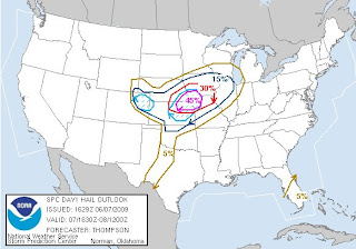
If the cap cools just a couple of degrees then we will have explosive thunderstorm development across eastern Kansas. for this reason, the SPC has issued a moderate risk for this area.

There is a chance the cap wont break and if that is the case then there will not be one thunderstorm in the area. It is extermemly hard to forecast such an event, but I think the cap will break and so does the SPC, but they have their concearns.
11:30 SPC discussion.
THE PRIMARY CONCERN ACROSS THE OUTLOOK AREA WILL BE THE STRENGTH OF THE CAP AND THUNDERSTORM COVERAGE THIS AFTERNOON/EVENING. REGIONAL 12Z SOUNDINGS SHOW THAT A VERY WARM EML HAS OVERSPREAD THE KS/OK WARM SECTOR...AND LOW-LEVEL MOISTURE IS STILL MARGINAL ACROSS TX/OK. WITH SURFACE TEMPERATURES OF 95-100 F NEEDED TO MINIMIZE CONVECTIVE INHIBITION ACROSS KS/OK...IT APPEARS THAT FOCUSED LOW-LEVEL ASCENT FROM THE TRIPLE POINT NEWD WILL BE NEEDED TO INITIATE THUNDERSTORMS THIS AFTERNOON...AS THE MID LEVEL WAVE APPROACHES FROM THE W. FARTHER S...STORM COVERAGE ALONG THE DRYLINE SHOULD BE MORE ISOLATED THAN PREVIOUS DAYS GIVEN THE DRYLINE LOCATION AT A LOWER ELEVATIONAND THE WARMER EML. THE 12Z NAM DEVELOP CONVECTIVE PRECIPITATION ACROSS NRN OK THIS AFTERNOON...THOUGH THIS MAY BE AN ARTIFACT OF MID LEVEL MOISTENING /WITH THE N-S CLOUD BAND CROSSING NW TX AND WRN OK/ TRIGGERING THE BMJ SCHEME IN AN OTHERWISE CAPPED PROFILE.
Any storms that fire may quickly become severe and wind shear is sufficient for rotating supercells to develop.

With these supercells, the updrafts will be very strong and may produce very large hail.
If the storms do form late this afternoon, I think as the sun sets, they will lose their single cell charactoristics and congeal into more of a damaging squall line. There is potential for widespread wind damage across northen Missouri. The tornado risk is still there with the squall line as you can get smaller cells spinning up the line.

I will update the blog if thunderstorms begin to fire. Stay tuned to your local news station and radio for any severe weather alerts.
I am going to leave you with a satelite picture of last night's MCS that moved across northern Missouri:

Alex Pickman

Here is the SPC Mesoscale Discussion:
A TORNADO WATCH IS LIKELY AT SOME POINT LATE THIS AFTERNOON. SOME UNCERTAINTY STILL EXISTS CONCERNING TIMING...BUT RAPID DEVELOPMENT OF SUPERCELLS APPEARS POSSIBLE AS EARLY AS 21-22Z. BENEATH THE CAPPING MID-LEVEL THERMAL RIDGE...A MOIST BOUNDARY LAYER IS BECOMING STRONGLY UNSTABLE WITH DAYTIME HEATING ACROSS EASTERN KANSAS INTO THE MID MISSOURI VALLEY. LATEST RUC GUIDANCE ALREADY INDICATES MIXED LAYER CAPE OF 2000-3000+ J/KG...CURRENTLY MAXIMIZED EAST AND NORTHEAST OF A WEAK WAVE ALONG STALLED SURFACE FRONT ACROSS NORTHEAST KANSAS. A NORTH-SOUTH UPSTREAM CLOUD BAND EVIDENT IN SATELLITE IMAGERY APPEARS REFLECTIVE OF AT LEAST A NARROW ZONE OF MID-LEVEL COOLING/LIFT SUPPRESSIVE OF INHIBITION. THIS IS EXPECTED TO OVERSPREAD MUCH OF THE REMAINDER OF THE EAST CENTRAL PLAINS BY LATE AFTERNOON...AND MAY BECOME SUFFICIENT... COUPLED WITH ADDITIONAL HEATING...TO SUPPORT THE INITIATION OF STORMS AS EARLY AS 21-22Z. HIGHEST PROBABILITIES APPEAR TO EXIST NEAR/WEST THROUGH NORTH OF TOPEKA...BEFORE SPREADING NORTHEASTWARD AND EASTWARD THROUGH THE REMAINDER OF THE AFTERNOON. DEEP LAYER SHEAR IS ALREADY BECOMING SUFFICIENT FOR SUPERCELLS... AND LOW-LEVEL HODOGRAPHS ARE EXPECTED TO BECOME INCREASINGLY SUPPORTIVE OF TORNADIC POTENTIAL...AS 850 MB FLOW CONTINUES TO BACK TO SOUTHERLY AND STRENGTHEN TO 30+ KT...AHEAD OF THE PRIMARY SHORT WAVE IMPULSE LIFTING THROUGH THE CENTRAL ROCKIES LATE THIS AFTERNOON
(Previous entry below)
-------------------------------------------------------------
After last night's MSC that moved east across northern Missouri and southern Iowa, it left 1-2 inches of rain northwest Missouri while locations just to the south got nothing. There are still som lingering showers across the area, but they will move off to the east allowing sunshine to take over.
With lots of sunshine and strong southerly winds, highs this afternoon will be in the 80's and low 90's around the area. The dewpoints are also going to be high today and with a frontal boundary and an upper level low approaching, thunderstorms have potential to fire. There is one poblem...the cap. The cap is a warm air inversion in the mid layers of the atmosphere which inhibits thunderstorm development.
If the cap cools just a couple of degrees then we will have explosive thunderstorm development across eastern Kansas. for this reason, the SPC has issued a moderate risk for this area.

There is a chance the cap wont break and if that is the case then there will not be one thunderstorm in the area. It is extermemly hard to forecast such an event, but I think the cap will break and so does the SPC, but they have their concearns.
11:30 SPC discussion.
THE PRIMARY CONCERN ACROSS THE OUTLOOK AREA WILL BE THE STRENGTH OF THE CAP AND THUNDERSTORM COVERAGE THIS AFTERNOON/EVENING. REGIONAL 12Z SOUNDINGS SHOW THAT A VERY WARM EML HAS OVERSPREAD THE KS/OK WARM SECTOR...AND LOW-LEVEL MOISTURE IS STILL MARGINAL ACROSS TX/OK. WITH SURFACE TEMPERATURES OF 95-100 F NEEDED TO MINIMIZE CONVECTIVE INHIBITION ACROSS KS/OK...IT APPEARS THAT FOCUSED LOW-LEVEL ASCENT FROM THE TRIPLE POINT NEWD WILL BE NEEDED TO INITIATE THUNDERSTORMS THIS AFTERNOON...AS THE MID LEVEL WAVE APPROACHES FROM THE W. FARTHER S...STORM COVERAGE ALONG THE DRYLINE SHOULD BE MORE ISOLATED THAN PREVIOUS DAYS GIVEN THE DRYLINE LOCATION AT A LOWER ELEVATIONAND THE WARMER EML. THE 12Z NAM DEVELOP CONVECTIVE PRECIPITATION ACROSS NRN OK THIS AFTERNOON...THOUGH THIS MAY BE AN ARTIFACT OF MID LEVEL MOISTENING /WITH THE N-S CLOUD BAND CROSSING NW TX AND WRN OK/ TRIGGERING THE BMJ SCHEME IN AN OTHERWISE CAPPED PROFILE.
Any storms that fire may quickly become severe and wind shear is sufficient for rotating supercells to develop.

With these supercells, the updrafts will be very strong and may produce very large hail.

If the storms do form late this afternoon, I think as the sun sets, they will lose their single cell charactoristics and congeal into more of a damaging squall line. There is potential for widespread wind damage across northen Missouri. The tornado risk is still there with the squall line as you can get smaller cells spinning up the line.

I will update the blog if thunderstorms begin to fire. Stay tuned to your local news station and radio for any severe weather alerts.
I am going to leave you with a satelite picture of last night's MCS that moved across northern Missouri:

Alex Pickman
posted by AlexPickman at
11:38 AM
![]()


0 Comments:
Post a Comment
Subscribe to Post Comments [Atom]
<< Home