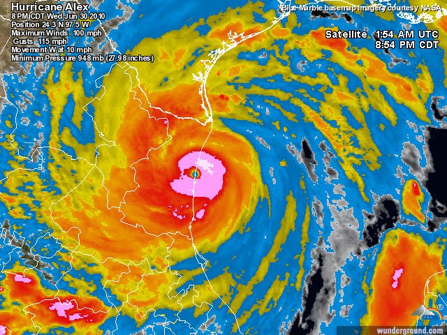
Winds now up to 100 MPH, and gusting to 115** (Category 2)
-----------------
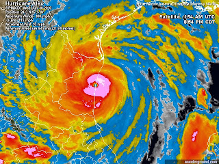
Hurricane Alex is strengthening as it aproaches the northern Mexico coastline. A pretty well defined eye has formed as the storm has tightened up and the winds increase. Winds now are currently at 90 mph, gusting to 115 mph. Further strengthening is possible, but the storm will make landfall as a Category 2 storm within the next few hours. Take a look at the visible satelite image below:
You can see the eye very clearly as the storm nears landfall in Mexico. Around that eye is where the most intense winds are located. This large hurricane is only moving about 12 mph allowing the eye to stay over the Gulf for a bit longer, thus may allow for some continued strengthening. The rains from Alex have already caused flooding from southern Texas into northeastern Mexico where much more is to come with this slow moving hurricane. 6-12 inches is likely in southern Texas.
With Hurricane Alex very close to landfall, there shouldnt be much more strengthening of the storm. I think the winds may increase to 105 mph or so, but it remain a category 2 hurricane. We are very lucky this storm wasnt still a day away, because with the dry air and other obstacles out of the way, conditions are very favorable for rapid strengthening. If this storm was still a day away we would likely be dealing with a very large and powerful major hurricane. But a category 2 for the first storm of the season isnt too shabby. Lets look at the history of this storm.
Alex formed as a Tropical Depression a ways south and east of the Yucatan Peninsula. It soon developed into a 60 mph Tropical Storm as it moved northwest and made landfall in the western Yucatan. It reamerged in the western Gulf of Mexico as a Tropical Depresion and rapidly intensified into a strong Tropical Storm as it moved nothward. The computer models were forecasting a more westward turn, so it was a waiting game to see when Alex would turn northwest. The storm did finally make the northwest turn which poised it directly toward Brownsville, Texas. The forecast was now for it to turn more westerly and aim Alex’s landfall in northern Mexico. The longer it stayed on the northwest track, the greater the chance of a US lanfall. the storm did finally turn west and Alex became the first hurricane of the 2010 season. The storm once again made a turn to the northwest, puting the threat back on the south Texas coast, but it remained south of the US and as mentioned, make landfall as a category 2 storm in northern Mexico.

Hurricane Alex will likely bring a storm surge of between 3-9 feet in northern Mexico and south Texas. A few tornadoes are also possible a the atmosphere is moderately unstable with plenty of moisture and wind sheer. Remember the most likely locations for tornadoes will be on the right side of where the storm makes landfall.
Another concearn with this Hurricane is the effects it has on the oil disater in the Gulf. Alex is creating rough seas over the Deepwater Horizon blowout location with 6-8 foot waves. The strong winds and rough seas will push oil into many of the bays and esturaries that havnt seen the oil yet. A storm surge of 1-2 feet along the Louisiana coast will allow the oil to press deeper into the very complex and fragile ecosystem of the marshlands.
Alex Pickman