Cold blast...some snow?
Dont expect any accumulation today. Just cold and winds with some rain and snow.
-----------------------------------------------------------------
This is a very complex and interesting storm system affecting us. Yesterday, we were in the warm sector with winds 20 to 40 mph. This created the setup for some thunderstorms to form durng the evening hours. The storm had some lightning and heavy rain with them, but the ingredients were not there for severe weather.
This morning was not bad with temperatures still in the 40's, but they have begun to drop into the 30's now and will continue throughout the day. Lets take a look at the current surface map below:

There is cold air and strong winds blasting in behind the cold front. Oklahoma City is reporting sustained winds of 36 mph, gusting to 44 mph.
The inverted trough extending northwest from the surface low will swing trough later and the winds will increase with the chance of some snow showers. I think there will be some accumulation, but it is hard to put a number on, so would say if you live north of I-70, a dusting to 2 inches is possible with higher totals occuring the further north you go. There is a Winter Weather Advisory in effect in northwest Missouri.
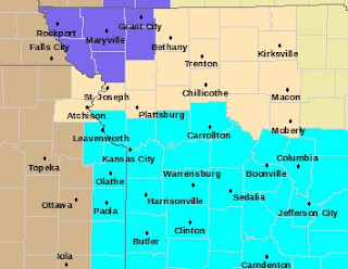
Now I havnt really talked about this much, but it is going o be very cold Monday and Tuesday morning. Take a look at the warning map below:

You can see the Winter Weather Advisory in northwest Missouri, but what is that light blue color? That is a Freeze Warning...As you can see it is south of Highway 36, but the entire area in that map above will see a hard freeze with temperatures in the low to mid 20's Monday morning, and even cold Tuesday morning with temperatures in the upper teens and low 20's. So plants need to be covered up.
There is another storm showing up Thursday. Here is the 18z GFS forecast valid Thursday:

I will have an update later.
Alex Pickman
posted by AlexPickman at
11:36 AM
![]()


0 Comments:
Post a Comment
Subscribe to Post Comments [Atom]
<< Home