7:00 PM Update....Storms raging!
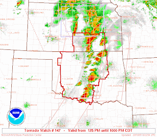
Thunderstorms have vigorously formed along the dryline in Kansas and Oklahoma where expected. There are currently 4 Tornado Watches issued across the southern Plains, but I want to fucus right now on th PDS (Particurally Dangerous Situation) Watch box. This watch extends from southern Kansas through Oklahoma. Take a look at the map below:
As you can see, the length of the Watch is lined with thunderstorms, and these storms are huge. As of right now, there have been 21 tornado reports, and there will likely be many more to come. There was just recently a tornado ripping through the southern Oklahoma City area and effecting highly populated areas including Norman and Moore, OK. This storm is now located east east of Okalahoma City racing ENE at 55 mph. Take a look at the current and impresive radar image of the is strong supercell below:

This storm means business and anyone in its path should take shelter immediately! The storm has had a history of tornadoes including ripping through OKC, damaging winds, and huge hail of baseball and up. Based on the radar image above, the storm looks to have possibly a large tornado on the ground so please seek shelter if you are in the path of this storm.
Here is a map of all the curent Severe Weather Watches: 

As you can see, the length of the Watch is lined with thunderstorms, and these storms are huge. As of right now, there have been 21 tornado reports, and there will likely be many more to come. There was just recently a tornado ripping through the southern Oklahoma City area and effecting highly populated areas including Norman and Moore, OK. This storm is now located east east of Okalahoma City racing ENE at 55 mph. Take a look at the current and impresive radar image of the is strong supercell below:

This storm means business and anyone in its path should take shelter immediately! The storm has had a history of tornadoes including ripping through OKC, damaging winds, and huge hail of baseball and up. Based on the radar image above, the storm looks to have possibly a large tornado on the ground so please seek shelter if you are in the path of this storm.
Here is a map of all the curent Severe Weather Watches:

This is an extremely dangerous event and should not be taken lightly. I wont have another update till around 1:00 AM, but there will still be storms rumbling then too.
Alex Pickman
posted by AlexPickman at
6:50 PM
![]()


0 Comments:
Post a Comment
Subscribe to Post Comments [Atom]
<< Home