Late night thoughts
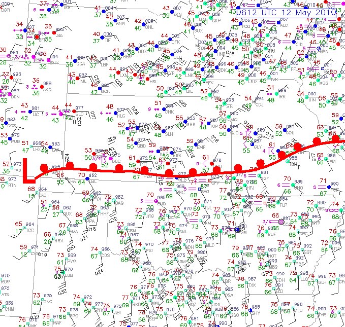
The frontal boundary that was stalled in Oklahoma has begun to surge northward. Take a look at the surface map below where I have drawn in the warm front.

The front has now pushed into southrn Kansas and Missouri and has set off showers and thunderstorms. Here is the current regional radar image:


The front has now pushed into southrn Kansas and Missouri and has set off showers and thunderstorms. Here is the current regional radar image:

The thunderstorms are forming along the warm front are slowly progressing northward. Notice how heavy the thunderstorms are over Missouri. They are growing in strength and coverage and are not moving much at all, moving over the same locations. This is creating a flodding problem. Also to add to that some of the thunderstorms have reached severe limits and are prducing hail and strong winds. The SPC has much of the area under a slight risk tonight tonight through Wednesday night. Take a look at the risk map:

There is currently no watches in affect for Missouri, but a large Severe Thunderstorm Watch is in affect for the southern half of Kansas. The thunderstorm threat will continue to psh northward through the overnight hours and Wednesday morning. By Wednesday afternoon, the warm front will likely be stalle over northeast Kasnas and northern Missouri. Temperatures south of the front will likey make a run into the lower to mid 80's with dewpoint possibly surging over the 70 degree mark. A cold front will approach the area Wednesday afternoon and with a arm and very moist airmass in place, thunderstorms will be a likely result. The SPC has much uf the area under a slight risk for severe thunderstorms for Wednesday afternoon as you can see below:

As mentioned above, we are dealing with a very warm and humid airmass behind the warm front. There are also other factors initiating the potential thunderstorms Wednesday afternoon. Mid Level CAPE value will surge between 3000 and 4000 J/KG. The warm sector, which is the area behind the warm front and ahead of the cold front, will be capped during the day Wednesday, but by late afternoon, several thunderstorms should begin to erupt in a scattered line from northern Missouri and southwest through eastern Kansas. This area, where the intial development will likely be, will be favorable for supercell thunderstorms to form due to strong wind shear. This may lead to isolated tornadoes.
Any thunderstorms that do form in this vicinity will have to be monitored closley as they may very quickly become supercellular and begin to rotate. Very large hail will also be a threat from these thunderstorms.
So overall, expect rain and thunderstorms to push northward overnight and tomorrow morning along the progressing warm front Some of these storms may be strong to severe with hail being the main threat. The front will stall over northern Missouri. Warm and very humid air will surge in behind the front and atmospheric conditions will be favorable for sevre thunderstorm development Wednesday afternoon as a cold front approaches the area. Initial development of thunderstorms will likely be from northern Missouri southwestward through eastern Kansas. Isolated Tornadic supercell thunderstorms may quickly develop in this initial development.
I will have an update tomorrow morning. This will likely be an active day.
Alex Pickman
posted by AlexPickman at
2:18 AM
![]()


0 Comments:
Post a Comment
Subscribe to Post Comments [Atom]
<< Home