Warm, rain, snow?!
Take a look at the current surface map below:
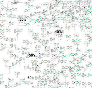


The temperatures should not get below what they are now, and when you wake up tomorrow morning, I think lows will be in the upper 30's to low to mid 40's. Warm air will surge in tommorow and here is what I am expecting for highs around the area:

Temperatures Wednesday night wont drop much at all...Likely only into the 50's. A cold front will be pushing south Thursday, and I think showers and thunderstorms will fire along this front as a low develops out ahead of the front near the area. The heaviest rain looks to fall northeast of Kansas City as the storm doesn't get too developed until it moves east of KC. So northeast Missouri and points east will likley see possibly up to an inch. If the low develops stronger just to the west of KC, the area of heavier rain will also spread west. The cold front will push through late Thursday afternoon and evening, and temperatures will crash into the teens and 20's Thursday night after highs in the 50's form KC northward, and 60's south of I-70.
The cold air will stay in place through the weekend, and this will set up the stage for a chance of snow on Saturday as a disturbence moves by. This disturbence is still really iffy, but looking at the lastest data, the chance is better. Right now I am going with a 30% chance, but I may up that tomorrow to a 40 or 50% chance dependent on the data.
Alex Pickman
posted by AlexPickman at
10:05 PM
![]()


0 Comments:
Post a Comment
Subscribe to Post Comments [Atom]
<< Home