Snow update....Updated
There is an area of extremely light snow forming in Kansas, and if any of it is reaching the ground, it would be very very light and powdery. It is also sleeting right now in Columbia, MO. This is still not looking like a major event in any terms north on I-70.
I will have more later this evening.
-------------------------------------------------
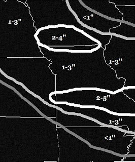
We are dealing with a very disorganized storm system that is poised to affect the southern Plains. Last night I thought a general 1-3 inches of snow may fall through Tuesday with higher totals of 2-5 inches to the south. Here was my snowfall forecast from yesterday valid through Tuesday:


I will have more later this evening.
-------------------------------------------------
We are dealing with a very disorganized storm system that is poised to affect the southern Plains. Last night I thought a general 1-3 inches of snow may fall through Tuesday with higher totals of 2-5 inches to the south. Here was my snowfall forecast from yesterday valid through Tuesday:

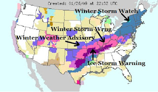
I dont this that will even be close to happening. We just dont have the right ingredients coming together for significant accumulations. There will be significant accumulations is southern Missouri where there are many weather advisories. Take a look at the current severe weather map below:

This shows the general track of the significant precipitation into the northeast where there could be a major snowstorm.
Here is my updated snowfall forecast through Tuesday for the area:

I am forecast up to an inch in northern Missouri, and gradually increasing the further south you go with 1-2 inches possible in central Missouri and 3-6 with locally higher amounts possible across southern Missouri. There is also an icing situation down south. How much will the ice accumulate? Here is my ice forecast:

This wil not be a major Ice Storm, but it will certainly cause problems on the roadways. There will also be some power outages with the heavier ice totals.
I will have an update later.
Alex Pickman
posted by AlexPickman at
3:57 PM
![]()


0 Comments:
Post a Comment
Subscribe to Post Comments [Atom]
<< Home